
Products
The MapEdit product family offers a suitable module for all tasks and requirements. Below you will find an overview of the MapEdit modules.
MapEdit
Professional
The link between CAD and database - efficient geodata processing with seamless CAD integration
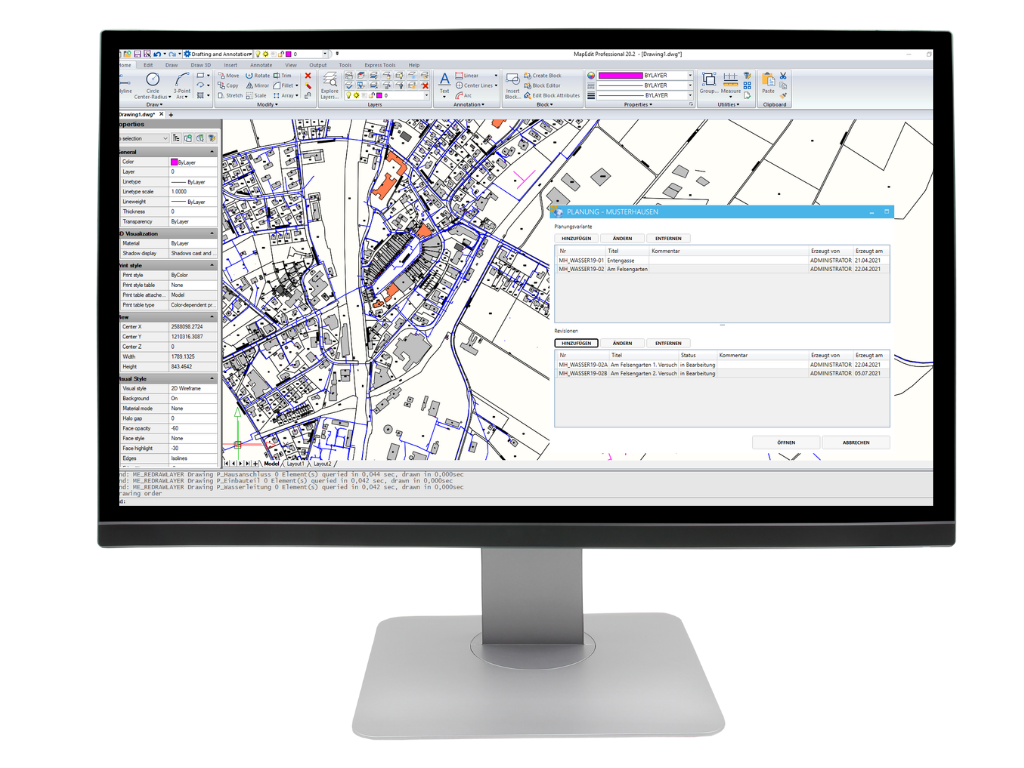
With MapEdit Professional, you combine powerful CAD functionality with direct access to geodatabases such as Oracle or PostgreSQL. Visualise and edit your geodata directly in a CAD system that is specially optimised for GIS applications. Whether as a plug-in for third-party CAD systems or as a stand-alone complete solution – you benefit from end-to-end digital processes and intuitive operation. This allows you to design your GIS projects more efficiently and precisely than ever before.
Manage complex pipe networks with intelligent linking and automatic error checking. MapEdit Professional supports you in the efficient modelling and management of supply networks by automatically detecting and checking the logical connections between network components. Faulty or inconsistent network structures are identified at an early stage so that corrections can be made directly in the system. This increases operational reliability and significantly improves the planning capability of your infrastructure projects.
Flexible CAD Connexion
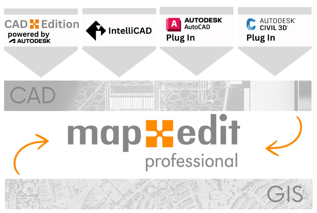
CAD-Edition
The complete CAD environment for MapEdit Professional includes a powerful CAD application based on an AutoCAD OEM core.This is installed directly within MapEdit Professional or can be used as stand-alone CAD software.This provides you with a proven, robust environment for your GIS processing – flexible and fully integrated.
IntelliCAD
The integrated complete CAD solution. MapEdit Professional is supplied with embedded IntelliCAD as standard.This stand-alone solution offers extensive CAD functionalities and enables seamless editing of geodata without additional software installation.
AutoCAD and Civil 3D Plug In
Seamless connection to AutoCAD, AutoCAD Map 3D and Civil 3D. For companies already working with AutoCAD (Map 3D) or Civil 3D, MapEdit Professional offers a highly flexible plug-in.This enables direct connection to existing AutoCAD environments and uses the integrated CAD engine to optimally visualise and edit geodata.
Powerful functions for professional GIS applications and CAD designs for customised planning
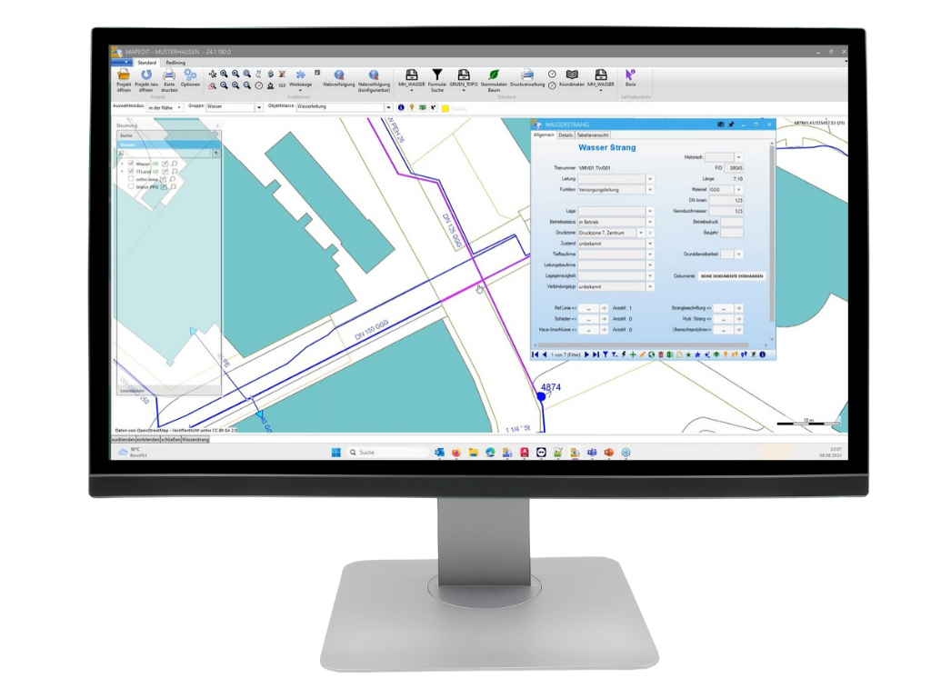
Develop and compare different scenarios for your projects directly in the CAD system. With MapEdit Professional, you can create, analyse and compare different design alternatives before a final decision is made. Thanks to the flexible layer and object management, different variants can be clearly displayed and customised. This allows planning processes to be optimised and well-founded decisions to be made on the basis of detailed analyses.
You can also use the complete CAD environment of MapEdit Professional to create customised designs for your GIS projects.Whether detailed site plans, infrastructure designs or civil engineering drawings – with the extensive drawing tools and parametric design functions, you can realise your ideas precisely. Direct integration with a geodatabase ensures that your CAD designs are always based on up-to-date and consistent data.
MapEdit Professional provides you with a powerful and customised solution for your GIS and CAD requirements.Maximise your efficiency, optimise your processes and benefit from the advantages of fully integrated geodata processing.
The bridge between CAD and GIS - for more efficient and precise geodata processing.
- Schematic plan and internal objects – Structured display and management of internal GIS objects for a better overview.
- Object snapping, dimensioning and labels – Precise measurement and flexible labelling for optimised visualisation.
- Spatial queries – analyse geodata with powerful search and filter functions.
- DWG, DXF, DGN, SHP import and export – compatibility with common CAD and GIS formats for maximum flexibility.
MapEdit
Desktop
Your powerful geoinformation system: Efficient analysis and visualisation of geodata.
MapEdit Desktop is the ideal solution for accessing and analysing geodata under Windows. The software enables flexible use in both online and offline mode and offers comprehensive functions for visualising, editing and analysing factual and geometric data.
MapEdit 3D-Viewer
Efficient plot function
Other functions:
- Data view & modification
- Search & Measure
- Network tracking
- Oblique image viewer
- Redlining
- Flexible data export
- thematic analyses
MapEdit
Mobile
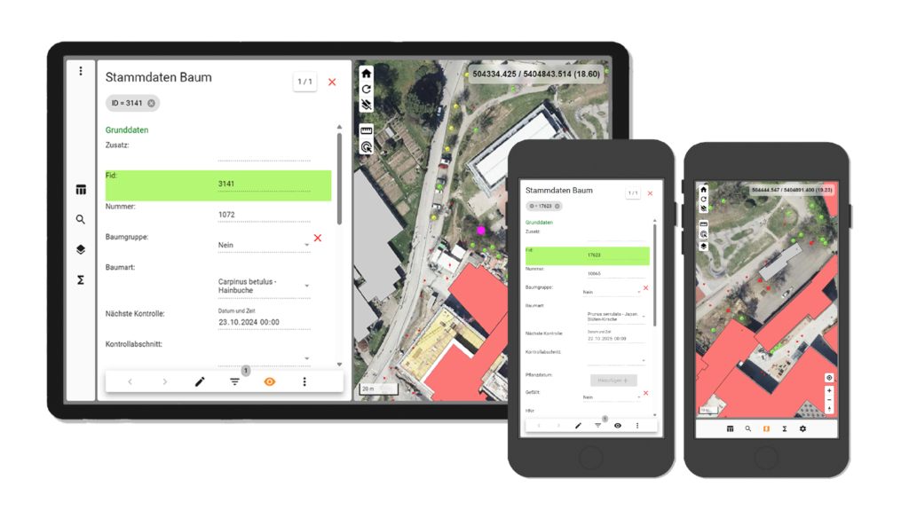
Your geoinformation system for travelling - flexibility you always have with you
Specially developed for use on tablets and smartphones, it gives you access to the same maps and data that you are used to from your workplace – regardless of whether you are out on inspections, maintenance or checks. This saves you time and increases your efficiency by simply taking your familiar working environment with you in your pocket.
Whether you want to run MapEdit Mobile on your own servers (on-premise) or use it as a flexible cloud service – the choice is entirely yours.
Work mobile as if you were in the office
The major advantage of MapEdit Mobile is its seamless integration into your existing GIS processes. On site, you not only have ‘read-only’ access to your maps and data, but can also carry out inspections, maintenance tasks and other control processes digitally and in real time. You work directly on the same database as in the office – without time-consuming data imports or exports and without manual synchronisation. Everything happens in a continuous digital process that simplifies your work and increases data accuracy at the same time.
Customised solutions for your requirements - flexibly expandable
With MapEdit Mobile, you don’t have to switch to a separate software solution, as is often the case with other providers. With MapEdit Mobile, you remain in the same environment as at your desk. This means: standardised data sources, standardised operation and one provider for all your GIS requirements. Everything from a single source, from a single manufacturer – this not only saves costs, but also complexity.
With the AppBuilder, you can create customised apps for iOS or Android that are perfectly tailored to your specific requirements, even without programming knowledge.If there are no standardised templates for your purposes – for example, when inspecting special trees or hydrants – you can easily put together your own app.Without the need for a developer, you can configure your mobile application using drag-and-drop and make it available to your employees immediately.
- Native app for iOS and Android or as a browser application
- Data view & modification
- Data acquisition incl. Photos
- 2-Factor-Authentication
- Search & Measure
- GPS Positioning
MapEdit
Portal
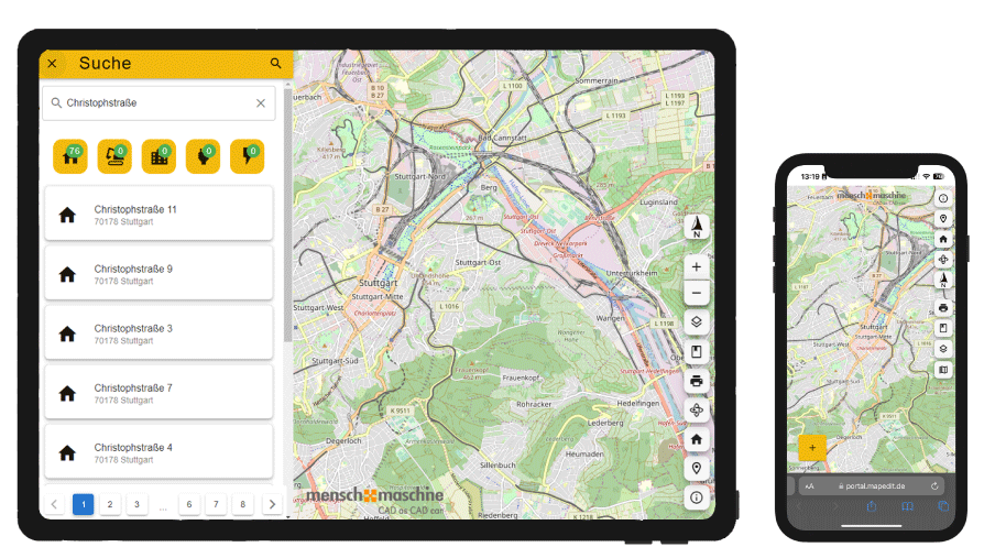
Your intuitive web GIS for all users: Fully responsive & user-friendly - perfect for municipalities, citizens & businesses.
MapEdit Portal is a fully responsive web GIS solution designed specifically for non-GIS users. With an intuitive user interface, it allows any user to quickly find their way around – without prior GIS knowledge. Designed as an information system, MapEdit Portal is ideal for municipalities, citizen GIS applications or companies that need a simple and accessible GIS platform.
Versatile visualisation options
Direct links
Other functions:
- Mobile First! – Full Responsive
- „Design Thinking“
- Designed for “non” GIS users
- Uncomplicated functionality
- Easy configuration with the AppBuilder
MapEdit
App-builder
The central configuration platform for all MapEdit products: One tool - unlimited possibilities for customisation.
The AppBuilder is the central tool for configuring all MapEdit products.You can use it to define forms, database and map connections, create customised display models and manage user and role rights. Changes are made once and are available on all MapEdit platforms and tools – for continuous, consistent administration.
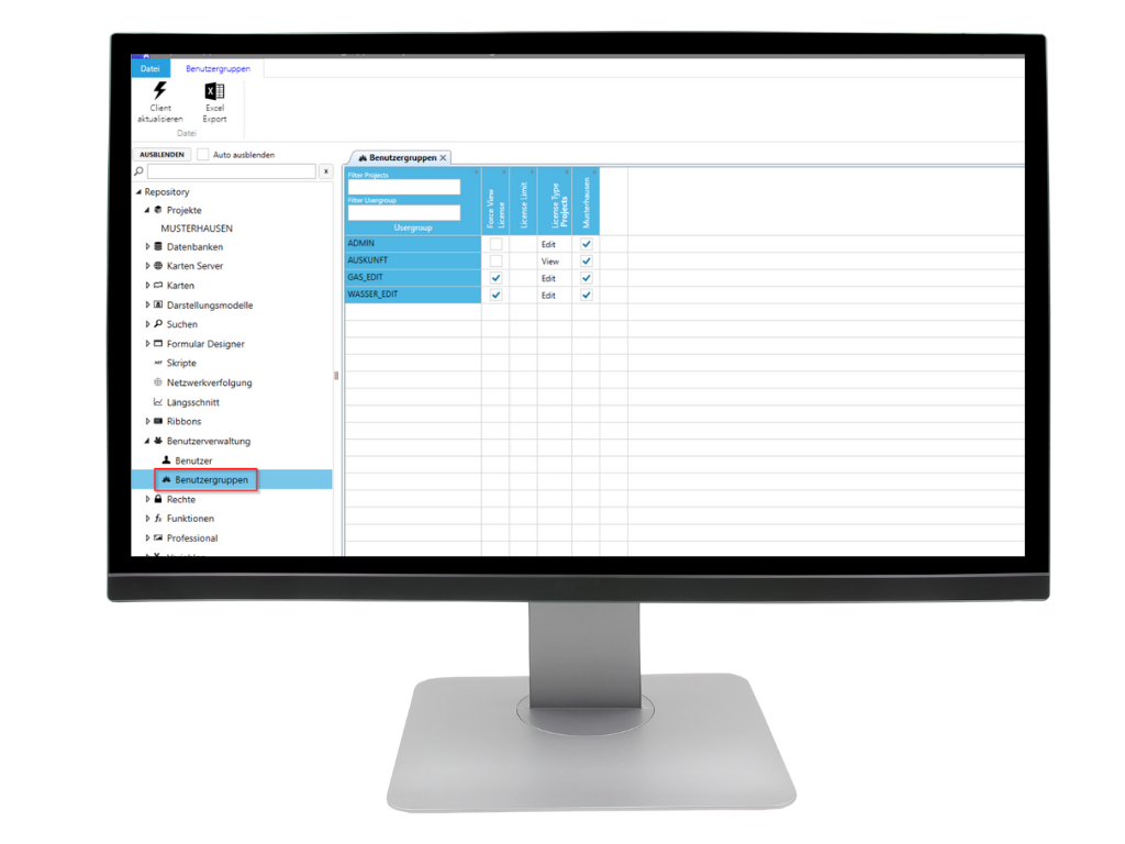
individual projects
detailed rights administration
Other functions:
- Create applications
- Central configuration of all MapEdit products
- Change/create database models
- Form Designer
- Presentation and rights administration
Interested?
Would you like to see for yourself what the software looks like live?
Then simply make a non-binding appointment for a demo.